Saturday, December 10, 2011

Falling in love at Twin Falls

Location: North Bend

Distance: 4 miles

I’ve seen far more awe-inspiring waterfalls than Twin Falls, but there’s something about its simplicity, and the simplicity it takes to hike there, that keeps drawing me in every time I have a spare hour left in the day. The river that flows along the path for the first half mile tells a different story every trip. There are always new mosses and mushrooms to identify. It’s just as fun to wedge my toes under a board on the bridge and lean out as far as I can to gauge the drop-off. I’m filled with the same sense of peaceful satisfaction each time I gaze up at the pure white stream stretching down over rock into the rushing torrents below. It’s a sure thing.

Friday, December 9, 2011

Just a ridge away

Location: Mount Rainier National Park

Distance: 6 miles

Elevation gain: 900 feet

The beauty of snowshoeing on Mazama Ridge is that you can amble off in any direction at any time without the constraints of a trail. We started at Paradise and headed south up the ridge, enjoying another clear day in the midst of winter. The sweating started as we climbed and kick stepped a half mile up a steep slope until we reached the ridge crest.

At the top, we turned back briefly to admire the Tatoosh Range in the distance and then proceeded to a small outcropping of rocks for lunch. Mount Rainier loomed just north, a glorious vision as we gobbled sandwiches and cookies. After a goofy photo shoot, we made a right and went south down the ridge through deep, powdery snow. We considered heading straight down the ridge but it was too steep for one in our party so we retraced our footsteps and made our way down the icy run by jamming our heels and zig zagging down the hill. We circled around Paradise Lodge and chalked it up to a mellow but beautiful day on the mountain.

Saturday, December 3, 2011

No hexes on this mountain

Location: Near Cle Elum and Roslyn

Distance: 7 miles

Elevation gain: 2,600 feet

This long, steady climb up Hex Mountain started on an old logging road that was covered with a few feet of snow. We passed through a few clearcuts as we wound our way upward and had a splendid view of Cle Elum Lake as we trekked the first two miles to reach the forest trail. We all placed bets on which lake it was and discovered we were all wrong once we pulled the map out during one of many water breaks. (Does Lake Pontchartrain count as a real guess?!)

The narrow path climbed a ridge crest, weaving in and out of large trees. It was a better workout than we were anticipating so there was a lot of silence as we dug our poles into the snow and waited for one of the few glimpses out of the forest. Eventually we came across a sign for Sasse Ridge and turned right up one final hill. The panoramic views of the eastern Cascades and beyond were unbeatable and we were fortunate to keep blue skies long enough to enjoy lunch and the scenery.

Friday, December 2, 2011

Glissading down PanPoint

Location: Mount Rainier National Park

Distance: 5 miles

Elevation gain: 1,700 feet

This classic trail isn’t much of a challenge, which made it just right for introducing two women to snowshoeing. We started the day in the Paradise parking lot and strapped our shoes on to start plowing through the snow. It was a transitional weather day, starting out gray and overcast but eventually giving way to bright blue skies. It was a straight shot up a series of small slopes to Panorama Point, where the clouds moved on and we could see the majestic Tatoosh range. With Mount Rainier looming gloriously in the background, I convinced one of my new friends to climb a nearby ridge and glissade down. A day of firsts! (For non-Washatonians, glissading basically means sliding down the snow on your butt.)

Monday, November 28, 2011

Too much of a Staircase

Location: Staircase, near Hoodsport

Distance: 6.5 miles

This was another adventure cut short. To take advantage of a rare sunny day and a forced day off, I eagerly looked forward to exploring a wild waterway - North Ford Skokomish River - beneath gigantic trees and ending at twin subalpine lakes. But then life happened. We got a late start, decreasing the odds of finishing the entire 15 miles. The last 1.2 mile of road to the trailhead was closed due to recent monsoon damage. Once we started up the path though, my feet found a soothing pace and my mind began to drift. It didn’t last long. We hopped across Slate Creek on slippery stones, balanced atop snow-covered logs and ducked under fallen trees. Then the trail disappeared. We kept blazing forward, satisfied every time we passed a ribbon tied to a branch, indicating we were still heading in the right direction. The trail proceeded past the remnants of a 1986 slide and came across an area that burned in a 1,400-acre blaze in 1985. Once we started climbing straight up above a cliff, slipping and sliding in the snow, it was time to turn around. My adventurous spirit was on vacation apparently, so we lingered near Lake Cushman and called it quits.

Saturday, November 26, 2011

A trickle of a waterfall

Location: Greenwater

Distance: 3.6 miles

Icy roads can foil even the most meticulously made plan. We had our sights set on Arch Rock, which sounded like a lovely opportunity to whittle away 12 miles on a rainy day. But after just a few miles on a forest road, dodging obnoxious snowmobilers speeding in the opposite direction and hogging the lanes, the ice and snow forced us to reconsider our final destination and turn around. After driving through Greenwater in search of any trailhead, we found ourselves in a parking lot signed Camp Sherman.

I didn’t expect much from a trail starting at a Boy Scout camp, and I wasn’t wrong. The first .6 miles were dubbed Moss of the Trees and it was a flat loop marked every few feet with a number. I nearly regretted my decision to hike as my partner made a game of yelling out the number as we passed by. Luckily, we quickly found another junction and a sign pointing us toward Snoquera Falls. The distance was far less than I had wanted but I never turn down a chance to see a waterfall.

The massive granite face was impressive and listening to the creek added a peaceful, easy feeling to the outing. As beautiful as the falls were, however, they had slowed to a trickle and hardly any water splashed down over the granite. I’m assuming spring is the time to visit Snoquera Falls when the snowpack is starting to melt off. Something to remember in a few months!

Monday, November 21, 2011

Ozette Triangle was just the right shape

Location: Ozette Triangle in the Olympics

Distance: 9.4 miles

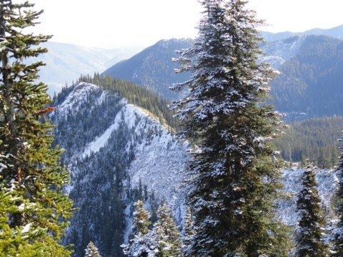
There is no beating the variety on this hike. It starts at one of the state’s largest bodies of freshwater, drops you onto a wild coastline and leads you through canopies of lush forest. Not to mention the deer, eagles and harlequin ducks that popped up along the way!

The loop began from the lake with a bridge leading over the graceful waters of the Ozette River. A quick right at the junction and I was off to stare wide-eyed at the Sitka spruce and western cedar that towered overhead. The planked boardwalk was a tad icy and I nearly lost my footing more than once, but I managed to stay upright. The trees eventually gave way to Ahlstroms Prairie, which was beautiful in its simplicity.

After 3.3 miles, I could hear the ocean and quickly dropped down a slope to Cape Alava. Sea stacks and forest-covered islands dotted the coast and inches of smelly seaweed covered the rocks. I carefully picked my way over the rocks to perch atop a large boulder and indulge in some Brie and bread – none of which I shared with the seagulls or deer that curiously watched me.

The most adventurous part of the trip was following the shoreline 3.1 miles south, squishing over bug-infested seaweed and balancing on slippery rocks. It amazed me how much longer it took to hike the beach than climb a peak. As I walked, the desolate scenery came to remind me of Middle Earth in Lord of the Rings.

I fruitlessly searched for petroglyphs an older couple had tried to direct me toward on some boulders dubbed the Wedding Rocks and then continued on to Sand Point, which marked the end of my coastal trek. I climbed the grassy knoll and gazed north and south up the shore, marveling at the sandy beaches marred by nothing other than an occasional light bulb carried in on the tide.

Eager now to work up another appetite and less impressed with the last 3 miles of forest after seeing such beauty on the beach, I fast-tracked my walk up another stretch of boardwalk to the ranger station, waved goodbye to the couple I had passed hours before and settled in for the long drive back to civilization.

Saturday, November 19, 2011

A true Hole-in-the-Wall

Location: Rialto Beach in the Olympics

Distance: 4 miles

Not quite ready to delve full-time into rain or snow, I opted to spend one of the last fall weekends on the coast. Rialto Beach is said to be one of the most spectacular sights in Washington so I made the more than three hour drive to the Olympics to wander on a sandy beach and listen to the waves crash on the shore. It was blue skies all weekend, but temperatures rarely crept above 32.

You only have to step out of the parking lot to be treated to the stunning sight of Rialto Beach, which stretches just beyond the Quillayute River. There are sea stacks, driftwood masterpieces and colorful cobblestones. The oft-photographed James Island made me leap with delight when I first saw it for I bought a framed snapshot that already hangs on the wall.

I spotted other off-shore islands as I moseyed along the beach, taking the time to admire the starfish and other marine life I found. A round log offered a way over Ellen Creek and my ultimate destination, Hole-in-the-Wall, could be seen another mile or so down the beach. The opening in the stone seemed to change size and shape depending on where I stood and I took more than a dozen photographs looking for just the way I wanted to remember it.

I lazed about on the downed timber for about an hour, enjoying the brightness of the sun and the lull of the waves. The approach of high tide, however, prompted me to start back toward one of the most heavenly sunsets I’ve ever seen.

Saturday, November 12, 2011

Anything is better than nothing in the snow


Location: Mount Rainier National Park, Longmire area

Distance: 5 miles

Elevation gain: 1,300 feet

This was a day that dampened aspirations but could not stamp out my need for a snowy adventure. The plan had been to climb to Camp Muir but recent storms and a lack of personnel stopped rangers from clearing the road to Paradise or even opening the gate to let us take our chances. Since we’d already driven nearly two hours and had no backup plan, we sucked it up and decided to take an easy stroll up Rampart Ridge.

I’d done the trail in summer and attempted it in the heart of winter so I couldn’t argue with the logic it made to hike it in fall. The path winds slowly through a forest before peaking out briefly at a viewpoint. Normally, hikers can see the river, the valley and nearby Tumtum Peak. I saw white: fog, clouds, snow. The trees were weighed down with powder and several inches coated the wet ground.

After skirting the cliff, I briefly rested and enjoyed my snowy view, trying to conjure up the images I saw here on my first exploration. I fondly recalled the gray jays that had swooped and stolen my snacks. The cold, however, quickly prodded me to finish the loop and return to the warmth of the car.

Friday, November 4, 2011

The right wrong turn on Thorp Mountain

Distance: 15 miles

Elevation: Probably 2,000 feet or so

Location: Salmon la Sac near Roslyn

Thorp Mountain was meant to be an easy, somewhat snowy summit to tag on a rare sunny day this time of year. My partner and I could practically hear the songbirds serenading us as we neared the end of our picturesque drive and began a hunt for a forest pass. After three stops and some backtracking, we were told no pass was needed since it is off-season so we parked and loaded up. We hadn’t gone but 100 feet when we were faced with our first challenge: crossing a cold, cold creek that offered no stepping stones or bridge. I bravely rushed forward and stretched my foot out to touch a rock barely breaching the surface. It was covered in ice. Somehow though, using our trekking poles and encouraging laughter (cameras at the ready for a fall), we made it over without incident.

The narrow path pushed through fields of crackling dry plants that had died some time ago. With the blue sky above and snow-capped mountains surrounding us, the brown only added to the kaleidoscope of color. We marveled over several bear tracks and settled into a comfortable hiking zone. After three hours, we passed a junction with the Kachess Trail and found ourselves staring out at the Cascade Range in the distance and No Name Ridge to our right. We had no luck finding the lookout tower that was supposed to signal the summit so we dug out our map and trail description and argued over where we were. Our answer came at the next junction that read: Thorp Mountain, 2.5 miles, with an arrow pointing back where we’d come.

More amused at our “detour” than discouraged, we followed our tracks until we found where we’d gone straight instead of curved left and continued our upward surge. I snapped a shot of the Thorp Mountain sign – just to prove our success, even if it took an additional five miles. The last stretch of trail was a bit unforgiving and I felt the soreness in my ankle settling in but I was distracted by the Christmas-looking trees that lined the trail and sparkling Kachess Lake below.

Then, in a blessed moment for my tired mind and body, I saw a rustic tower (built in 1931) perched atop the hill. We threw our packs down and stared in wonder at the Enchantments rising in the distance, the lakes glistening below. Our celebration was stinted though since the approaching night spurred us down the trail, barely pausing on the hidden ice patches. Despite it all, can’t say I regret our poor navigation a bit!

Reverse hike in Mowich

Distance: 8 miles

Elevation: About 2,000 feet

Location: Mowich area of Mount Rainier National Park

The infamous 17-mile road to Mowich gave me no problems as I sped along and I wondered why I’d felt such hatred toward the pot-hole haven last year. I'd had visions of a mini-summit in mind all morning but the road crushed them after all. The gate on the last 6-mile stretch was closed due to snow and ice so I was forced to park and improvise. I found myself on a reverse hike, meaning I trekked downhill and put in the work uphill on the return to the trailhead.

I settled on Paul Peak Trail, which drifted downward through an old-growth forest on generic switchbacks that didn’t pound the knees too badly. The scenery wasn’t stellar but the birds kept me company as I tromped past the junction with the Wonderland Trail and hiked another mile to Mowich River. The frigid water and snow-swept trees in the distance were the highlight of the trip so I didn’t linger long before heading back to the warmth of my car.

Thursday, October 27, 2011

Rainy in the Hoh

The day was cold and wet - what better to do than visit the Hoh Rain Forest? I've already plugged through the moss-laden trees and slept beside the river on the approach to Mount Olympus, but this was just a side trail, a minor detour on the day we pointed the car for home. It's dubbed the Trail of Mosses and it's kept short for tourists who want to get out of the vehicle but don't want to expend a tremendous amount of energy (we're talking less than a mile here).

Everything was bright green, a sharp contrast to the dreary gray day. Even the water contained clumps of electric green moss. The trail made a quick loop through the forest, offering interpretive signs and views of maple groves and natural arches growing overhead. Just the right walk to wave goodbye to the Olympics.

Thursday, October 20, 2011

Standing on the edge of the U.S.

Location: Neah Bay

Cape Flattery is the most northwestern point of the contiguous United States and it is worth the long drive and short walk necessary to take in the beauty. It’s at the tippy top of the Olympic Peninsula on the Makah Indian Reservation, tucked in a secluded corner amid cavernous coves and crashing waves.

The walk is ¾ of a mile through a mossy wonderland complete with cedar decks to stand on and gaze out on the turquoise water. This is where you catch your first glimpse of the miniature islands that dot the coast, and possibly the puffins and gray whales that frequent the area.

At the end of the trail, you find yourself on the edge of a cliff and faced with nearby Tatoosh Island. The Makah once used the island as a fish and whaling camp but it has most recently been turned over to the Coast Guard. Staring out at the whitecaps, I noticed a gray whale disappearing beneath the surf and determinedly walked the ridge until I caught his tail in my camera lens.

It’s such a lovely place to relax, it’s hard to tear yourself away.

Boggy and the beach

Location: Neah Bay

Shi Shi Beach is said to be one of the region’s most spectacular beaches but it has been mired in problems since the idea of adding it to Olympic National Park first arose in the 1970s. Land-access disputes with the Makah Indian Tribe were finally settled in 1976 and the sandy beach with gorgeous sea stacks became a national treasure.

The 4-mile trail to access the beach is a boggy nightmare that leads you down a muddy road bed that only gets muckier and threatens to swallow your feet whole. The first mile treks through a Sitka spruce forest, which warrant more attention than hikers give it because so much of the focus is on staying afloat in the bog and praying for the occasional planked bridge.

In just under two miles, you reach the park boundary and begin descending a 150-foot bluff to the beach below. It’s a bit rough on the knees but the driftwood-littered beach is a hidden gem worth a little pain. The tide was coming in when we arrived and the Point of the Arches (sensational sea stacks) loomed down the beach.