Saturday, August 28, 2010

Cascades worth a second look. And a third.

"A strong man and a waterfall always channel their own path."

The Twin Falls hike was pleasantly surprising. The climb was minimal and within a short mile, I found myself staring in awe at a cascade that tumbles 150 feet over a rock wall. And that was just the beginning.

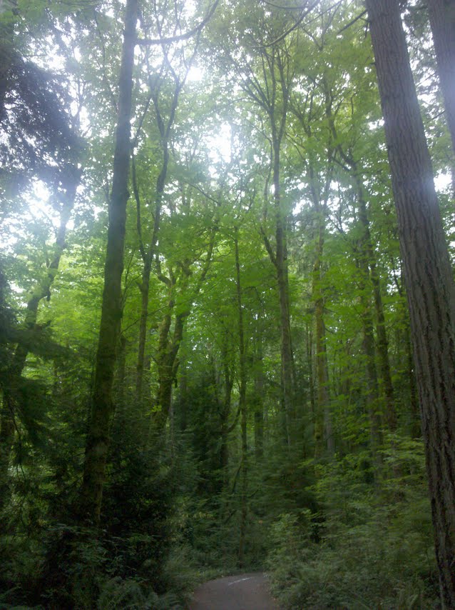
In this rainy patch of Washington (90 inches annually!), the forest more closely resembles a rain forest than the wooded forests I've become accustomed to. The path stays flat for some time, following a raging river that flows over smooth stones. I was struck by how green everything was. The trees, the boulders, everything was covered with a rich coat of moss. Nursery logs litter the trail's side, providing a close-up look at how smaller trees grow out of those that have fallen.

The dreaded switchbacks appear after 10 minutes or so but they're quick and painless. At the top, there is a wooden bench for those who want to catch their breath and try to catch a glimpse of the falls between the overgrown tree branches. The path continues on to a massive fir tree that is old enough to warrant a sign begging passersby not to trample its roots.

From there, it's up and down on the trail and you can finally see the lower falls and the river gorge below.
It stopped me in my tracks, but it was far from the best view I'd have.

There is an offshoot to the trail after the first mile. Following the steps down to a little overlook, I got an incredible view of the mighty falls pounding over the rock wall. The water dropped into a churning pool with a cave to the side where random pieces of wood had been pushed by the torrent.

Another half mile of walking led to a bridge between the two waterfalls. Looking up, I could see the upper falls squeezing its way through a narrow gorge and crashing
down.

The water rushed beneath the bridge and over the lower falls, though I couldn't see the second cascade because of the angle. But seeing the engorged river stretch into the distance was view enough.

There were a lot of people moseying around the area but most of them seemed content to reach the bridge, snap a few photographs for the family album and head back. I, of course, let curiosity get the best of me and pressed on. After another two miles of the same scenery, I grew weary of the deafening noise of the freeway (which met with the trail some time after the waterfalls) and turned back.

My favorite sight that day appeared as I paused one last time to admire the Twin Falls. I wedged my feet beneath the sturdy boards of the bridge and leaned over as far as I could. It was a long drop into frothy white waters - I could have stood there staring all day.

A cold hike to a peaceful lake

" I hear lake water lapping with low sounds by the shore... I hear it in the deep heart's core." -- William Butler Yeats

The eight-mile trip for a glimpse of Talapus Lake, one of several in the Pratt Lake basin near North Bend, wasn't as picturesque as other hikes have been but there was something more special about sitting beside the still water.

It wasn't chilly as I hiked up the first three miles of the path, stopping from time to time to
admire the many mini waterfalls that run across the trail or inspect massive leaves and tiny red berries. My favorite were the spooky-looking trees with clumps of stringy moss hanging from the branches.

The fog was thick and obscured views of
Snoqualmie Valley. But the forest was undisturbed and there was no one else walking in the area so it was a decent trade-off. Just after two miles or so, the trail curved east away from a rock waterfall set back a few feet. The water splashed down and streamed away in a creek that dropped down a gully.

From there you enter the Alpine Wilderness and have a choice to take a side path to Talapus and Ollalie lakes or keep straight and hike to Pratt Lake, which is another two miles. Since the views are not supposed to be any different at Pratt, I embarked on the downward slope until Talapus Lake revealed itself set deep in a basin. It was splendid to see.

The water was perfectly calm and the mountains surrounding it reflected like a mirror on the surface of the lake. There's always a blissful moment when coming upon something as naturally beautiful as a hidden lake but the temperature dropped swiftly and I found myself shivering in no time. When my fingers turned white and went numb, I reluctantly headed back toward the parking lot with the thought of finding another hike in area where the mercury would be over 50!


Saturday, August 21, 2010

Meadows on The Mountain

Flowers are the sweetest things God ever made, and forgot to put a soul into. ~Henry Beecher

With wildflowers abounding around Mt. Rainier, I decided to find a less frequented area of the park. It paid off. The drive to Spray and Seattle parks, which are magnificent meadows in the Mowich area, was an adventure in itself. You have to drive 16 miles over a loose gravel, pot-holed road that is nothing less than bone-jarring. I arrived at Mowich Lake and hardly paused to admire the peaceful, still waters surrounded by evergreens and a sheer cliff before bouncing down Spray Trail, eager to begin the 13-mile journey.

The first item of interest on the trail was Eagle Cliff, a viewpoint that puts you right in Mt. Rainier's face. The mountain looked massive from here.

A distant thundering sound could be heard after the first series of switchbacks, roughly 1.5 miles in, and then a sign suggesting a short detour to Spray Falls appeared. I took it, of course, picking my way over an area of small stones until I could see what looked
like an ordinary waterfall with water cascading over boulders. I walked a bit further and craned my neck up to see an aptly named waterfall, the water zigzagging its way down with a fine mist spraying several hundred feet out. I crawled up two fallen branches and crossed slippery rocks for a better look before wistfully turning back to the main trail.

The switchbacks made a comeback but they weren't nearly as painful as recent hikes. I climbed 600 feet in a half mile, enjoying the mini moss-covered falls wedged into the forest.

There was nothing to notify me that I had arrived in Spray Falls. All of a sudden, the forest disappeared and a green meadow opened in front of me with bunches of
purple, yellow, pink and white flowers. I haven't yet learned all the names of the wildflowers but it smelled like a lily factory and I laughed out loud several times, content in this magical land where the only sound is bees buzzing around you. I skipped along the path, amazed that there were broad meadows beyond every turn.

I had probably gone another two miles before I realized that Spray Park was way behind me but I felt pulled forward like a magnet, wanting to know what else existed
along the path. Mt. Rainier was a stunning backdrop to the never-ending meadows and a series of craggy rocks could be seen on the other side of the trail. I pushed on past the first snowfield, still determined to reach the end, but stopped about two miles beyond that because I wasn't equipped for ice and I was getting cold in my shorts and tank top.

Regretfully, I rested on a ridge overlooking Seattle Park and then headed back. It was then that I had my first run-in with marmots. The first one that a fellow hiker pointed out was fat,
waddling near a pond, but was too far away to get a good look at his face. The second one I spotted was scampering through a bunch of lavender daisies and sat straight up when he heard me coming. He stood for a few seconds, clearly hoping I would move on, and scurried into a hole when I stubbornly stood there hoping for a better picture. The third one was my charm. He was close to the trail and didn't seem frightened of me at all. The marmot sat on a rock for a while, then ran through the flowers as I inched closer. Without much warning, he turned and ran down the path directly toward me, veering to the side at the last minute while I made my departure.

I hiked back to the parking lot, happy that I'd found what I came for. Delicate wildflowers, a long walk through nature and sightings of the creatures lucky enough to live there.

Tuesday, August 17, 2010

Sighing up Mt. Si

"Never measure the height of a mountain until you have reached the top. Then you will see how low it was." -- Dag Hammarskjold

I had not planned on tackling Mt. Si when I woke up Saturday. It was #3 on my list of interesting, challenging hikes to squeeze in this summer. But since my alarm didn't rouse me when it was supposed to, I got on the road too late to drive too far so I chose a closer mountain.

Local mountaineers told me Mt. Si is a must for all hikers in the region but to expect company. Lots of it. They were right. I couldn't walk more than a few feet before passing someone coming down the mountain or pausing for a break on the way up.

I hit the trailhead at 11:52 a.m. and the sun was beating down with record-breaking temperatures (for Washington) that soared into the mid-90s. Luckily, the trail gradually climbs through a shaded conifer forest and all I saw of the sun was little glimmers through the trees.

It's a well-maintained trail and looked like it would be a gradual walk up the 3,700-elevation climb. I set off with great enthusiasm, taking note of the still, hot air and wondering why there were no birds chirping. About 20 minutes in, the steepness hit me and I started grumbling under my breath about the unusually warm weather, getting a late start, choosing yet another steep hike, having long hair that blankets my sweaty neck.

The 1.0 mile sign brought little relief since I knew there were seven miles left but it did give me a sense of renewed strength. Before I knew it, I found myself in Snag Flats, which thankfully leveled out for a few moments so I could take in the burnt trunks. A wildfire raged through here for weeks back in 1910 and the charred remains of forest are easily spotted among the regrowth.

I kept trucking and got a kick out of the signs posted every half mile so you could see how fast (or slow) you were ascending. You know it's a tough climb when they include markers every half mile!


Just when my lungs were starting to really burn and my blisters were giving me guff, I trudged past the 3.5 mile sign and came upon massive rock outcroppings and a rather rewarding view of Mt. Rainier and other peaks in the area. I could even see Interstate 90 in the distance.

Since this was an obvious place to rest, I decided to plop down on some boulders and eat a banana and some grapes. My naturally sweet treats attracted plenty of bugs but I was delighted when a beautiful reddish orange butterfly landed right on the banana peel and stayed for the duration of my breather. The view was nice but I had been told that the pinnacle of the mountain was where the best outlook was so I stood back up and the butterfly flitted off.

A rock gully was the next obstacle but was relatively easy - as long as you watch where your feet land. On the other side was one last winding uphill trail and then a sign pointing left for Snoqualmie Viewpoint. At last.

That sight, how the world just opens up and you're no longer in
a forest or scrambling over rocks, was phenomenal. I could see rolling green hills in the backdrop, stands of trees, entire cities with clusters of houses and roads, a piece of a calm river circling the mountain base. Downtown Seattle stood in the distance, clear as day to see. I could even hear the band that had been playing at a weekend festival in North Bend when I passed through hours before. It was surreal to be sitting in the middle of nature after such an ascension, looking down on civilization.

I sat for nearly an hour, marveling at the sight and enjoying the sunshine and solitude. Then I headed back downhill, gathering enough speed that I hardly stopped to look around. One thing did catch my attention
though. Somewhere around mile six, I heard chirping. Since I had been so shocked earlier to not hear birds, I halted in my tracks and started searching for the tweeter. It ended up being a fluffy, bottom-heavy animal that looked to be something like a gopher. He was sitting on a branch far too small in the heights of a tree, chirping like a bird. I stood and stared for a while, trying to figure out if he was stuck or injured or simply singing to passersby. I never did figure it out but I left him there in the tree and concentrated on the last few miles.

The parking lot was an awfully nice sight that day.

Sunday, August 8, 2010

Priest Point Park in the rain

In America, with all of its evils and faults, you can still reach through the forest and see the sun. But we don't know yet whether that sun is rising or setting for our country. -- Dick Gregory

Priest Point Park is a stone's throw from downtown Olympia but all signs of city disappeared as I pulled into the park. A rose garden is the first thing that greeted me but there was a wedding about to start and since a summer rain was already pelting the men decked out in tuxes, I decided not to add to their stress by intervening in their reserved spot.

The forest encompasses 314 acres and offers the Woodsy Wonder Trail for those who want to stroll among the trees and ferns. This land was once inhabited by missionaries
of the Oblates of Mary Immaculate in 1848. They set up shop here - building the garden, a chapel and school to teach boys from nearby Indian tribes. (The mission closed in 1960).

I crossed a wooden bridge and found myself at an immediate crossroad in the dirt path. Veering right, I could see several fallen trees in the forest that now had tiny trees and vines growing out of them. The trail almost immediately came upon what looked to be a natural recycling area for the city. Piles of top soil, wood and other items were neatly stacked and labeled. I kept to the right of every trail intersection and marveled at how luminescent the green leaves were in contrast to the shadowy darkness of towering moss-covered tree trunks.

After dashing across East Bay Drive (yes, the wilderness found a way to intersect with modern roads), I started the trek to Ellis Cove. The hike follows windy, hard-packed dirt paths with smoothly carved wooden handrails for those who need stability or a
rest making it up the semi-steep trail. It was during one of these rests that I happened to look up and see a black bear that someone had carved out of wood and attached to a tree.

After a half hour or so of climbing up a hill, the trees open up just enough to catch a glimpse of murky brown water between
the bare branches. The water is stagnant and still, the only movement coming from a handful of ducks who were nesting on the saltwater shoreline. There are fallen logs bordering the water and patches of wetland grass on the edges.

After pushing through another uphill path, the trail evens out
and stumbles across a pebble-covered beach with views of the Port of Olympia and the Capitol Building. The weather was rainy, overcast and foggy so I couldn't see more than vague outlines and impressions of the boats and buildings. Curious how chilly the water was, I dipped my big left toe in the cloudy water and then noticed the sign warning of contamination and telling those who come in contact with the water to immediately shower. So much for untouched nature!

Thursday, August 5, 2010

History of Titlow

If you want to understand today, you have to search yesterday. ~Pearl Buck

My first experience with Titlow Park was forgettable. I pulled into the parking lot to finish a phone call, looked around briefly and dismissed it as a run of the mill park. But this is one of those places that find its beauty in history, in the path it took to today.

The land was first used as a campsite by the Puyallup and Nisqually tribes in the 1800s. In 1903, an attorney named Aaron R. Titlow bought 30 acres of the Wilton Land Claim and set out
to build the 3-story Hotel Hesperidos. The hotel was styled after a Swiss Chalet and featured 30 rooms, a billiard room and barber shop. It was wildly successful but shut down shortly after Titlow died in 1923, reopening once more five years later as Titlow Beach Lodge. It still stands today on the edge of the park though its dark wooden frames house a summer camp for children. When Metro Parks of Tacoma bought the land in 1926, they removed the top two tiers of the lodge.

The old lagoon where hotel guests once swam is mostly dried up now. A stream of water flows from a large pipe and winds its way into a small pool of water that is only alluring to the brown geese and ducks who roam the area. The bottom of the lagoon is thick muck with a few boulders strewn around.

A gravely path - or a wellness path, as one jogger referred to it - circles the park. It runs around the water, past the playground and through a shaded patch of forest before ending up in front of a public swimming pool constructed in the 1950s.

Unremarkable, save for its history.

The park is partnered with Titlow Beach, which is a short jaunt down the road and across the railroad track. There's a covered dock with benches for those who want to gaze out on the Sound or gawk at the nearby Narrows Bridge. It is here that octopus wrestling championships were held in 1963.

Seriously.

It was a world event with 111 divers competing. They were tasked with diving down and grappling with giant octopuses to pull them out of a cave and out of the
water. Sounds easy enough but these are the largest octopuses in the world - weighing in at 90 pounds - and have suctions cups on their arms.

Nowadays, Titlow a slice of rocky beach that stretches as far as the eye can see. Several wooden logs poke up from the shallow water and the shell of what looks like it was once a building sits 50 feet out in the water.

The intrigue is in its past.

Wednesday, August 4, 2010

Back to the bridge

As promised, here is a link to the article I wrote about the repainting being done on the new Tacoma Narrows bridge. Make sure you check out the photo gallery, where a very talented professional displays his daredevil shots.

The story ran last week. Sorry for the delay but I was on vacation. Now, back to exploring the South Sound!