Location: Alpine Lakes Wilderness
Main objective: Mount Cashmere
Distance: A long way…
Elevation gain: At least 8,501 feet
The Enchantments are an area most climbers in Washington dream of going but rarely do since there are few permits and a lot of interest. We lucked out and got a five-day permit for the Eight Mile Area, which doesn’t encompass the most challenging peaks but had enough to keep us preoccupied for our mini-vacay.  We started out slow, promising that we would take things day by day rather than pushing to summit as many peaks as we could physically handle. It took a few miles before we passed all the day hikers and paused to enjoy a snack at Little Eight Mile Lake, which we immediately designated as our “bath” spot on the
  descent. The trail then began to climb rather steeply, winding up a series of switchbacks that finally brought us high enough that we could see two lakes below and the impressive mountain range in the distance.
It was a decent climb, more strenuous than I’d been expecting  with my 50-pound pack (I’d shoved a LOT of chocolate in, for bribery, reward, motivation, you name it), but I was distracted by the colorful wildflowers long enough to forget the pain. We finally reached Lake Caroline and stopped to filter water, debating whether we should throw the tent up or push on. Since the shoreline seemed to be a breeding ground for black flies and mosquitoes, I armed myself with bug spray and begged to keep trekking to the meadows at the base of our first destination.
In another two miles, we came around a ridge and found ourselves in Windy Pass. The meadow was so inviting we couldn’t help but follow the stream to a flat, grassy area beneath the trees and pitch our tent. The area lived up to its name – the wind blew so hard and frequently through the night that I never quite shook the shivers.
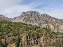
 In the morning, we made our tea and started for the ridge. It was a rocky path that traversed more than two miles to the mountain, which didn’t seem very big the closer we got. Mount Cashmere, at 8,501 feet, is the 58th tallest peak in the state and comprised completely of boulders. Sensing a long haul ahead, we dumped everything but our food and climbing gear, figuring we’d have to come back that way after summiting since our next peak was in the opposite direction.
After what seemed like an eternity on the ridge, peering below at unnamed lakes and possible  rock routes to climb in the coming days, we found ourselves at the base of Cashmere. We crossed some snow gullies to the back of the mountain and scrambled up some sketchy boulders before realizing we had somehow missed the path. We examined our options (summiting the east side of the peak, traversing the top of the rocky mountain, etc.) and decided to drop our packs and climb straight up. Daylight was waning and we still had a long way back to our remaining gear, which we’d hidden in the bushes near Windy Pass.
 All things considered, it didn’t take long to scramble to the summit and gaze out at the Enchantments, which were captivating. I could see Dragontail Peak and Cannon Mountain, which are high on my list to tackle. On the way back to the pass, we somehow lost elevation on the ridge and found ourselves several hundred feet below our original trail. My partners decided we would keep trucking over the loose shale, which took me out twice, further swelling my screwy ankle and bloodying my left knee. I don’t know that I’ve ever been so excited to return to the day’s starting point! But, there was chocolate.


 I arrived at the sparkling lake after 5.5 miles, anxious to dig my feet in the cool water and let the sun warm my face. Unfortunately, there is a backdoor to Valhalla and dozens of families had beat me to the spot. I tried relaxing beside a fisherman for some time, but it wasn’t long before the splashing of dogs and shrieks of young children nudged me on my way. Still, it was pretty as a postcard.